


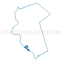
SWATARA TWP DIST 03, Dauphin County, Pennsylvania
About
Outline

Summary
| Unique Area Identifier | 658999 |
| Name | SWATARA TWP DIST 03 |
| County | Dauphin County |
| State | Pennsylvania |
| Area (square miles) | 4.26 |
| Land Area (square miles) | 1.81 |
| Water Area (square miles) | 2.45 |
| % of Land Area | 42.49 |
| % of Water Area | 57.51 |
| Latitude of the Internal Point | 40.22660400 |
| Longtitude of the Internal Point | -76.82603520 |
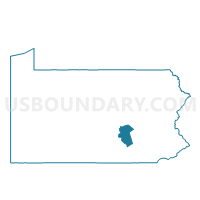
Maps

Graphs
Select a template below for downloading or customizing gragh for SWATARA TWP DIST 03, Dauphin County, Pennsylvania


Neighbors
Neighoring Voting District (by Name) Neighboring Voting District on the Map
- FAIRVIEW TWP DIST 02, York County, PA
- FAIRVIEW TWP DIST 04, York County, PA
- HARRISBURG WD 01 DIST 02, Dauphin County, PA
- HARRISBURG WD 01 DIST 03, Dauphin County, PA
- HIGHSPIRE DIST 01, Dauphin County, PA
- LOWER SWATARA TWP DIST 03, Dauphin County, PA
- NEW CUMBERLAND WD 01 PCT 01, Cumberland County, PA
- NEW CUMBERLAND WD 02 PCT 01, Cumberland County, PA
- STEELTON WD 01, Dauphin County, PA
- STEELTON WD 02 DIST 01, Dauphin County, PA
- STEELTON WD 02 DIST 02, Dauphin County, PA
- STEELTON WD 03 DIST 01, Dauphin County, PA
- STEELTON WD 03 DIST 02, Dauphin County, PA
- STEELTON WD 04, Dauphin County, PA
- SWATARA TWP DIST 01, Dauphin County, PA
- SWATARA TWP DIST 02, Dauphin County, PA
Top 10 Neighboring County Subdivision (by Population) Neighboring County Subdivision on the Map
- Harrisburg city, Dauphin County, PA (49,528)
- Swatara township, Dauphin County, PA (23,362)
- Fairview township, York County, PA (16,668)
- Lower Swatara township, Dauphin County, PA (8,268)
- New Cumberland borough, Cumberland County, PA (7,277)
- Steelton borough, Dauphin County, PA (5,990)
- Highspire borough, Dauphin County, PA (2,399)
Top 10 Neighboring Place (by Population) Neighboring Place on the Map
- Harrisburg city, PA (49,528)
- New Cumberland borough, PA (7,277)
- Steelton borough, PA (5,990)
- Highspire borough, PA (2,399)
- Bressler CDP, PA (1,437)
- Enhaut CDP, PA (1,007)
- New Market CDP, PA (816)
- Oberlin CDP, PA (588)
Top 10 Neighboring Unified School District (by Population) Neighboring Unified School District on the Map
- Central Dauphin School District, PA (90,401)
- West Shore School District, PA (62,415)
- Harrisburg City School District, PA (49,528)
- Middletown Area School District, PA (18,076)
- Steelton-Highspire School District, PA (8,389)
Top 10 Neighboring State Legislative District Lower Chamber (by Population) Neighboring State Legislative District Lower Chamber on the Map
- State House District 92, PA (68,932)
- State House District 88, PA (65,490)
- State House District 106, PA (64,016)
- State House District 103, PA (62,609)
Top 10 Neighboring State Legislative District Upper Chamber (by Population) Neighboring State Legislative District Upper Chamber on the Map
Top 10 Neighboring 111th Congressional District (by Population) Neighboring 111th Congressional District on the Map
Top 10 Neighboring Census Tract (by Population) Neighboring Census Tract on the Map
- Census Tract 229, Dauphin County, PA (8,386)
- Census Tract 236.02, Dauphin County, PA (5,566)
- Census Tract 214, Dauphin County, PA (5,233)
- Census Tract 233, Dauphin County, PA (4,158)
- Census Tract 202.20, York County, PA (4,081)
- Census Tract 108, Cumberland County, PA (3,517)
- Census Tract 201, York County, PA (3,430)
- Census Tract 235, Dauphin County, PA (2,399)
- Census Tract 234, Dauphin County, PA (1,832)
Top 10 Neighboring 5-Digit ZIP Code Tabulation Area (by Population) Neighboring 5-Digit ZIP Code Tabulation Area on the Map
- 17111, PA (30,714)
- 17057, PA (21,329)
- 17104, PA (20,962)
- 17070, PA (15,692)
- 17113, PA (10,749)
- 17319, PA (10,417)
- 17034, PA (2,414)